


RICHMOND, Va. — A major ice event is impacting Virginia on Sunday. All of Virginia is now under a winter storm warning for the weekend. We're bringing you the most up-to-date information on the winter storm as it impacts Virginia. Click here for the latest weather forecast.

WINTER WEATHER RESOURCES
Weather Alerts | Closings & Delays | Interactive Radar | Map Center
Sunday, Jan. 25
11:02 p.m.
Laura French reports on very icy conditions in Chesterfield, where she attempted to stick a ruler in the snow and couldn't break the surface.
10 p.m.
According to a news release, AAA Mid-Atlantic has helped nearly 400 drivers in Virginia. AAA noted that more than half of the calls were for vehicles stuck in the snow.
AAA advises all drivers to stay off the roads until conditions improve.
“Fewer vehicles on the road also provide a safer environment for road crews and first responders, including tow drivers, to do their jobs,” said Morgan Dean, AAA Mid-Atlantic spokesperson in Virginia.
9:25 p.m.
Chief Meteorologist Zach Daniel gives an update, noting that power outages remain low considering the amount of ice in the forecast.
Precipitation has now moved out of the region, toward the coast.
9:06 p.m.
The Virginia State Police (VSP) shared an update on crashes throughout the state. As of 9 p.m., VSP has responded to 378 crashes statewide, 28 of those had reported injuries. Eighty-six of those crashes were in Central Virginia (Division 1), two with reported injuries.
"Drivers should stay off the roads tonight and into Monday morning. If you are on the roads, give VDOT trucks and emergency crews room to do their jobs. Also understand that storm impacts could delay emergency response to stranded motorists," VSP said.
8:30 p.m.
After traveling from CBS 6 to Chesterfield County and back Sunday evening, Melissa Hipolit shared an update on road conditions as freezing rain falls in Richmond.
"I've been able to see what the roads are like, and I want to tell you, they are not good."
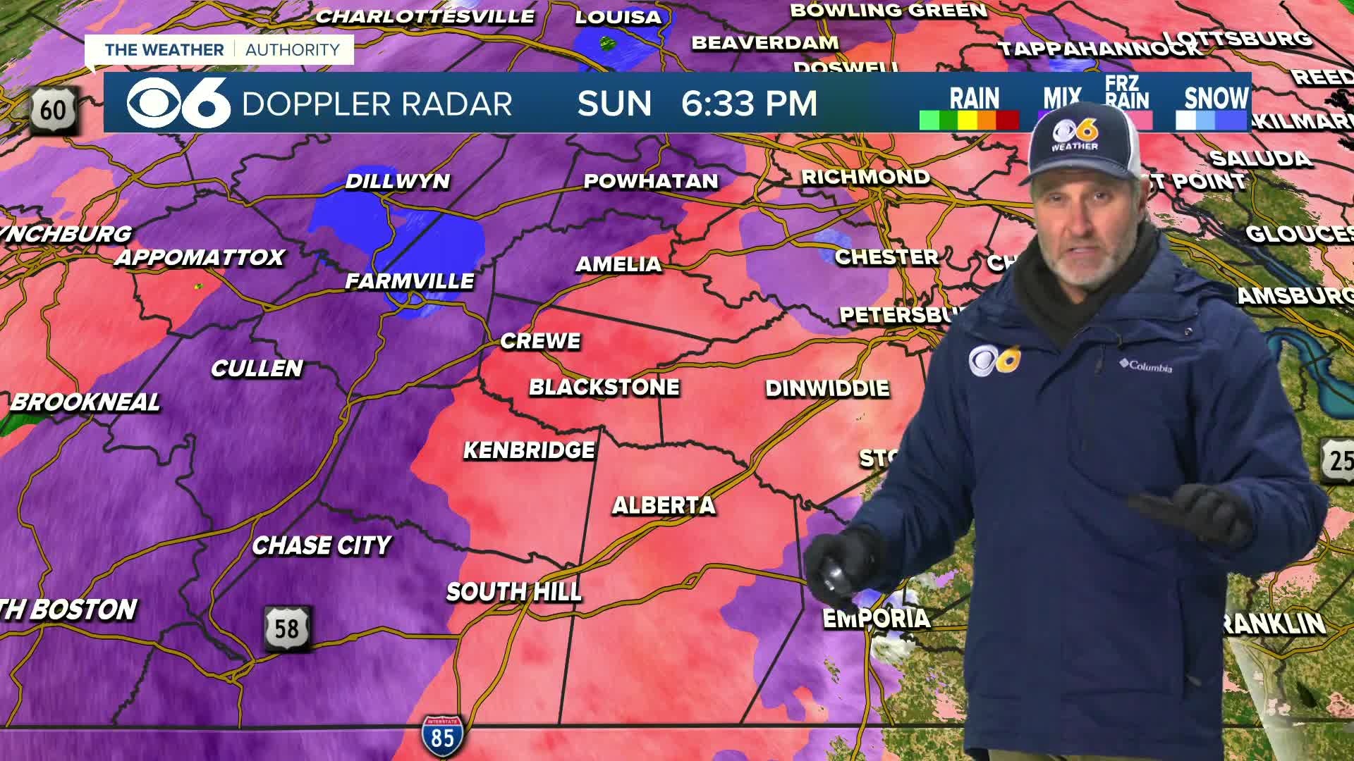
7:25 p.m.
The next few hours Sunday evening are critical, as freezing rain mixed with sleet could lead to ice accumulation across the Richmond area. Meteorologists Zach Daniel and Mike Goldberg say that sleet has limited total ice amounts compared to earlier forecasts, but the Winter Storm Warning remains in effect until 7 p.m. Monday. Precipitation should taper by around 9 p.m. on Sunday, though freezing drizzle may persist overnight and into early Monday, keeping roads slick. Temperatures are expected to rise to 35°F Monday with sun helping to melt ice, but the week ahead will bring some of the coldest weather in years, with highs in the 20s and lows in the single digits.
6:58 p.m.
Katie Carter, an emergency response specialist with the National Weather Service, says she's expecting power outages to spike overnight and into Monday.
"We're expecting outages tomorrow to actually go up, so there will likely be worse power outages tomorrow due to the weight of the ice and then the gusty winds that come in after the storm leaves," Carter said.

Local News
NWS expects power outages to spike overnight into Monday
6:30 p.m.
The final wave of precipitation from the winter storm is intensifying across the Richmond area, with a mix of roughly 50% freezing rain and 50% sleet. Chief Meteorologist Zach Daniel says if sleet dominates, it could significantly reduce the risk of power outages compared to heavier freezing rain.
The Winter Storm Warning remains in effect until 7 p.m. Monday. Sunday night temperatures are keeping roads “super slick” through the night.
5:25 p.m.
Chesterfield County is opening a dedicated call center specifically for non-emergency questions and needs related to the winter storm. The number is (804) 751-2362.
It will be open 8:30 a.m. to 5 p.m. M-F during the storm. Spanish-speaking staff will be available.
5 p.m.
VDOT officials are urging Virginia drivers to stay home Monday morning as wet pavement from Sunday's winter storm is expected to refreeze overnight, creating dangerous driving conditions.
"Drivers should wait for conditions to improve before resuming travel until at least mid-morning on Monday," VDOT officials said. Read more.
4:45 p.m.
Laura French ventured out in her Chesterfield subdivision on Sunday afternoon to file this report.
"The sleet is coming down and we have seen periods of freezing rain as well," Laura said. "Definitely, the roadways are covered. In our neighborhood, that's the only place I've been, secondary roads are a mess. Now we do have four-wheel drive, I had my husband take me out."
4:30 p.m.
CBS 6 Chief Meteorologist Zach Daniel is urging everyone in the Richmond area to stay off the roads Sunday evening as heavy sleet transitions to a dangerous wave of freezing rain. The most serious threat is expected between 6 p.m. and 9 p.m. Sunday, when the final band of precipitation arrives.
4:00 p.m.
Henrico Police are urging people to avoid walking in roadways as freezing rain and ice conditions continue through the night. Police said they have seen numerous people walking in streets to avoid snow banks left by the snowstorm. However, they are strongly discouraging this practice.
While police said they understand people wanting to avoid deep snow, they emphasized walking in snow banks is much safer than walking in roadways where drivers may have difficulty stopping on icy surfaces.

2:30 p.m.
Sleet has been falling across Richmond since early morning, but a significant wave of freezing rain is expected later today, likely causing widespread icing on trees and power lines and leading to power outages. Road conditions, especially on side streets, are currently very poor, and travel is strongly discouraged unless absolutely necessary. Ice accumulations of 0.25 to 0.5 inches are possible across central and southern Virginia, posing serious hazards through tonight.
Watch Zach's 2:30 p.m. Winter Weather Update
1:00 p.m.
This crash on Interstate 64 west near I-295 in western Henrico County has been cleared.
No one was hurt when this truck jackknifed on the interstate around 9 a.m. during Sunday's winter storm.

12:40 p.m.
Petersburg City Public Schools will be closed on Monday and all after-school activities are canceled, officials with the district said.
Noon
Meteorologist Mike Stone says Winter Storm Warnings will continue into Monday. Precipitation is expected to transition from sleet to freezing rain, potentially causing significant ice accumulation. There is a high risk of power outages, especially in Central Virginia, where up to half an inch of ice could accumulate. The storm is expected to impact travel through Monday, with the precipitation tapering off from west to east tonight. Detailed forecast.
11 a.m.
Virginia State Police have responded to nearly 250 crashes, 16 with injuries, as of 11 a.m. on Sunday, according to officials with the agency. Fifty-six of those wrecks, one with injuries, were in the Central Virginia/Richmond division.
"Drivers should stay off the roads now through the day Sunday and into Monday morning," troopers urged. "If you are on the roads, give VDOT trucks and emergency crews room to do their jobs. Also understand that storm impacts could delay emergency response to stranded motorists." Read more.
10:50 a.m.
While Richmond Public Schools' schools and offices will be closed on Monday, students are being told to work "asynchronously."
"Preschool and elementary students were provided with packets on Friday, and secondary students should use their Chromebook and check Canvas for their assignments," officials said. All work must be completed by the first day back for credit."
10:20 a.m.
Meteorologist Mike Stone says sleet will change to freezing rain from southeast to northwest. Some warmer air in eastern and southeastern Virginia will allow for highs to get above freezing, changing coastal areas over to plain (non-freezing) rain.
10:15 a.m.
Meteorologist Tom Patton and Storm Rider 6 have picked up reporter Kelsey Jones. They checked out conditions along Midlothian Turnpike while headed back to Richmond.
10:10 a.m.
VDOT cameras show crews working to clear Interstate 64 on Afton Mountain on Sunday morning. Click here to check out road conditions from VA511.
10 a.m.
Hanover County Schools will be closed on Monday. Hanover County government offices, solid waste convenience centers, parks and recreation facilities, all courts and Clerk’s offices, will also be closed Monday.
Henrico County announced that all general government offices, facilities, courts, and clerks’ offices will be closed Monday, Jan. 26, due to the winter storm. Read more.
More than 255 closings and delays for Sunday and Monday have come into the CBS 6 newsroom. Click here for the updated list.
9:15 a.m.
Meteorologist Tom Patton says snowplow drivers in Hanover County are doing a "terrific job." A big thanks to all the crews who are out working in the storm!
8:40 a.m.
Colonial Heights police update road conditions in the Tri-Cities of Virginia
8:00 a.m.
Bill Fitzgerald finds 'powdery, icy snow' in Tuckahoe
6:30 a.m.
Brendan King updates conditions in the Scott's Addition neighborhood of Richmond, Va.
6:15 a.m.
Caroline Coleburn sees sleet in Midlothian: 'My front yard is covered'
6:00 a.m.
Reba Hollingsworth updates conditions in Short Pump, Va.
3:45 a.m.
Share what conditions are like in your neighborhood. Be sure to include the time and your location. Click here to comment on the WTVR CBS 6 Facebook page. You can also email pics@wtvr.com.
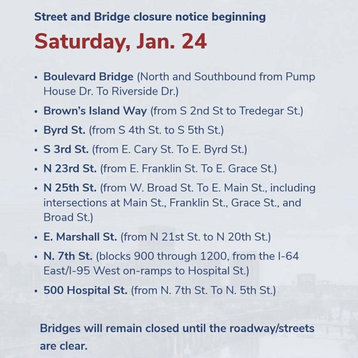
12:05 a.m.
These bridges and roads are closed in Richmond. The Boulevard Bridge closed around 10 p.m. Saturday.
"Exercise extreme caution if you must travel," city officials warned.
12 a.m.
More than 210 closings and delays for Sunday and Monday, have come into the CBS 6 newsroom. Click here for the updated list.
Saturday, Jan. 24
11:20 p.m.
A.J. Nwoko filed this report from Storm Rider 6 along Broad Rock Road. The team was headed back to Richmond around 11:20 p.m. on Saturday when they spotted a crash.
11:15 p.m.
CBS 6 Chief Meteorologist Zach Daniel and Meteorologist Mike Goldberg are pinpointing the timing of when this dry, powdery snow will change to sleet and eventually to freezing rain on Sunday. Stay safe and bring your pets inside.
10:45 p.m.
A driver was critically injured in a three-car crash that closed a road for hours in Chesterfield on Saturday.
9:45 p.m.
Virginia State Police have responded to 60 crashes, 6 with injuries, as of 9:30 p.m. on Saturday, according to officials with the agency. Eleven of those wrecks were in the Central Virginia/Richmond division.
"Drivers should stay off the roads now through the day Sunday and into Monday morning," troopers urged. "If you are on the roads, give VDOT trucks and emergency crews room to do their jobs. Also understand that storm impacts could delay emergency response to stranded motorists."
8 p.m.
More than 200 closings and delays for this weekend — and Monday, have now come into the CBS 6 newsroom. Click here for the updated list.
7:15 p.m.
A wreck has closed Buford Road in both directions between Pinetta Drive and Jahnke Road in Chesterfield. Officers said Buford is expected to reopen around 8 p.m.
6:45 p.m.
CBS 6 Chief Meteorologist Zach Daniel and Meteorologist Mike Goldberg have an updated look at potential snow/sleet accumulations for Central Virginia.
Watch full report
4:15 p.m.
Richmond is opening the City Emergency Shelter at 5 p.m. at Southside Community Center located at 6255 Old Warwick Road. The shelter will remain open for the duration of the storm. Residents with pets should call Richmond Animal Care and Control at 804-646-5573 for limited temporary pet housing (service animals are always permitted in the shelter). The Salvation Army Inclement Weather Shelter (1900 Chamberlayne Avenue) and CARITAS Surge Shelter will continue operating as planned. Click here for Richmond shelter updates.
The Main Library (101 E. Franklin St.) will serve as a central warming center today until 5 p.m., and
3:15 p.m.
We've added an hour-by-hour gallery of the storm through 1 a.m. Monday. Click here to check it out.

Weather News
Updated hour-by-hour look at winter ice storm in Virginia
1:15 p.m.
More than 155 closings and delays for this weekend — and Monday, have now come into the CBS 6 newsroom. Click here for the updated list.
1 p.m.
The Virginia National Guard has staged approximately 300 soldiers and airmen at facilities across Virginia ahead of the storm. Response crews are coordinating with regional emergency managers and are equipped with heavy-duty tactical trucks capable of traveling through deep snow. Read more.
Noon
Gov. Abigail Spanberger warned in a news conference Saturday that Virginia faces a "catastrophic" winter storm with dangerous ice accumulation, significant snowfall and extended power outages. She urged all residents to stay off roads from Saturday evening through at least Monday morning. The state has received federal emergency declaration approval, and FEMA representatives are now on the ground. All state agencies are operating under 24-hour emergency protocols.
"Please use these final hours to be prepared, to make sure that you have blankets and warmth and food to make it through this storm," Spanberger said.
9:15 a.m.
The Federal Emergency Management Agency (FEMA) announced that President Donald Trump has approved federal disaster assistance for Virginia because of the massive winter storm.
The action authorizes FEMA to coordinate disaster relief efforts statewide to "alleviate the hardship and suffering caused by the emergency on the local population and to provide appropriate assistance to save lives, to protect property, public health and safety and to lessen or avert the threat of a catastrophe in the entire Commonwealth."
8 a.m.
More than 100 closings and delays for this weekend — and Monday, have come into the CBS 6 newsroom. Click here for the updated list.
7:30 a.m.
Need to get caught up on all of the preparations, updates from city and county officials, as well as the forecast? We've added a "complete coverage" clip so you can watch a 16-minute segment from CBS 6 News Saturday Morning with Greg McQuade and Mike Stone.
Watch full report
Click here for our live updates and winter storm coverage from Friday, Jan. 23.
POWER OUTAGE RESOURCES
Dominion Energy | Central Virginia Electric | Mecklenburg Electric | Northern Neck Electric | Prince George Electric | Rappahannock Electric | Shenandoah Valley Electric | Southside Electric
🌨 Winter Storm Prep Tips
Snow vs. Ice Prep
- Clear most snow before ice arrives — leave just a thin layer so ice doesn’t stick directly to surfaces.
- Keep snow at ~½ inch so sunlight can help melt it — too much reflects heat away.
Protect Outdoor Heating/Cooling Units
- Keep vents, blades, and tops clear of ice & snow.
- Don’t use sharp tools to scrape ice — could damage equipment.
Thermostat When Leaving Town
- Lower to ~60°F but don’t turn heat off.
- Keeps system from fully shutting down (saves energy + prevents reboots).
If Power Goes Out & Temps Stay in the Low 20s or Below
- Shut off main water supply.
- Open faucets to drain pipes to avoid bursts.
- Fill the bathtub for toilet flushing and pots/pans for drinking water.
- If temps aren’t as cold, you may have 1–2 days before pipes are at serious risk.
Watch full report
📱 Download the CBS 6 Weather App for iPhone and Android.
Closings | Interactive Radar | Weather Alerts
iPhone News App | Android News App
iPhone Weather App | Android Weather App
Depend on the CBS 6 Weather Authority to keep you ahead of the storm. Watch CBS 6 News and stay with WTVR.com for complete coverage of this winter blast.


