

RICHMOND, Va. -- It is slightly cooler and not quite as muggy this morning. Skies are clear to partly cloudy, and areas of fog will be possible.
Highs today will be a degree or two cooler, and the heat index will be slightly lower. Highs will be 95-100°, and the heat index could break 105°. A heat advisory is in effect until 8 p.m.

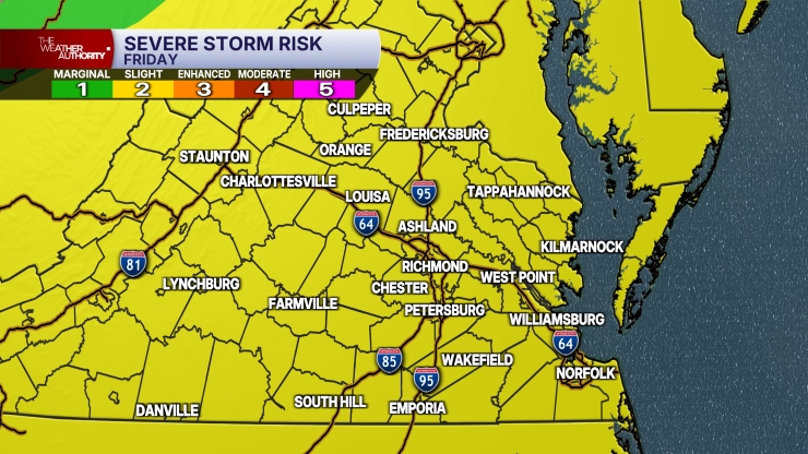
Widely scattered storms will be possible this afternoon and evening. They should be not be quite as prolific as yesterday, and storm chances will be higher north and west of Richmond. Storms will produce frequent lightning and could have some hail. We also have a marginal (level 1 out 5) to severe (level 2 out of 5) risk of severe storms with damaging wind gusts.
Once again, any storm that develops could produce torrential downpours and localized flooding.
Monday will be a few degrees cooler with highs 90-95°, and a heat index 95-100°. Scattered storms will be around during the day, with activity increasing for the evening. There is a marginal risk (level 1 out 5) for severe storms with strong winds. Heavy rainfall will continue to be a threat.
Tuesday will have some storms around, especially towards evening. It will be a little cooler with highs in the upper 80s and lower 90s.
The rest of the week will be muggy with the chance of a few pop-up storms each day. Highs will be in the mid to upper 80s Wednesday, the lower 90s Thursday, and the low to mid 90s Friday.
As of now, it looks like next weekend will have highs in the low to mid 90s.
Stay With CBS 6, The Weather Authority.
STORM TRACKING LINKS:
Weather Alerts
Closings & Delays
Interactive Radar
Map Center
📱 Download the new and improved CBS 6 Weather App for iPhone and Android.


