

RICHMOND, Va. -- It will be another hot and very muggy day. Highs will be near or a little above 100°, and the heat index will break 110°. An Extreme Heat Warning is in effect until 8 p.m.

A few isolated storms are possible by around 2 p.m., mostly west of I-95. The chance for scattered storms will increase by late afternoon, and last through around mid-evening. The best chance of storms in the metro is approximately 5-8 p.m.
The threat of storms is not very high, but any storm that does develop could be severe with damaging wind gusts. Storms will also have frequent lightning, and due to the muggy air, will produce torrential downpours. Over one inch of rain will be possible in under 30 minutes, and localized flooding is possible.
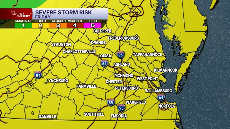
Much of the area is under a slight risk (level 2 out of 5) for severe storms with damaging wind gusts, but areas north and northeast of Richmond are under an enhanced risk (level 3 out of 5).
Sunday will be a few degrees lower, but highs will still be 95° to 100°, and the heat index could break 105°. A heat advisory may be issued. The threat for storms on Sunday is lower, with the best chance of storms north and northwest of Richmond by late afternoon or early evening. There is a marginal (level 1 out of 5) to slight (level 2 out of 5) risk of severe storms with strong gusts.
More scattered storms will be around on Monday with highs in the low to mid 90s.
Tuesday could have a few isolated storms with highs around 90°.
Highs will be in the upper 80s to around 90° on Wednesday.
The heat will increase a little more later in the week, with some low to mid 90s on Friday.
Stay With CBS 6, The Weather Authority.
STORM TRACKING LINKS:
Weather Alerts
Closings & Delays
Interactive Radar
Map Center
📱 Download the new and improved CBS 6 Weather App for iPhone and Android.


