


RICHMOND, Va. — A significant winter storm is expected to impact Virginia this weekend, bringing what could be the most substantial snowfall the region has seen in years.
The storm presents a rare combination of abundant moisture and extremely cold air that could result in heavy snow accumulations across central Virginia beginning Saturday evening and continuing through Sunday.
"This is not necessarily unique, but it is a rare event for not just us here in Virginia, but a lot of states here across the nation's midsection and even into the Deep South as well," said CBS 6 Chief Meteorologist Zach Daniel in a Tuesday afternoon livestream.
Watch Replay: A look at the major winter storm that could bring heavy snow to Virginia this weekend
The Arctic air mass moving into the region could be the coldest experienced in years, with temperatures potentially dropping below zero early next week. Saturday's high temperatures are expected to reach only the low 20s, with evening temperatures falling to around 18-19 degrees.

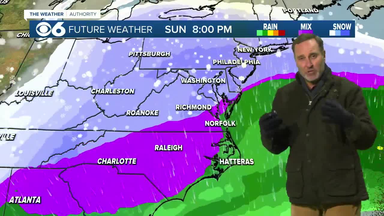
Today's Forecast
Winter storm likely this weekend
While snow appears to be the primary precipitation type expected, sleet and freezing rain remain possible due to complex atmospheric conditions. The surface temperature does not solely determine precipitation type, as mid-level atmospheric warming can occur even when ground temperatures are well below freezing.
The storm system is being driven by a disrupted polar vortex, which typically keeps Arctic air locked around the North Pole. When disrupted, this cold air spills southward across large portions of the United States.
Current forecast models show the storm beginning Saturday evening, with most of Saturday expected to remain clear. However, conditions are expected to deteriorate Saturday night, making travel hazardous.
The combination of heavy precipitation and sustained cold temperatures means any accumulation will stick and persist, unlike typical Virginia winter storms where marginal temperatures often limit impacts.
Residents should prepare for potential power outages and travel disruptions that could last several days. The extreme cold following the storm poses additional risks, including frozen pipes and dangerous wind chill conditions.
While specific snowfall totals are not yet clear due to the storm being several days away, all indications point to a high-impact weather event requiring serious preparation.
The forecast will continue to be refined as the storm approaches. Check back for the latest updates at wtvr.com/weather.
STORM TRACKING LINKS:
Weather Alerts
Closings & Delays
Interactive Radar
Map Center
📱 Download the new and improved CBS 6 Weather App for iPhone and Android.

This is a developing story. Email the CBS 6 Newsroom if you have additional information to share.
📲: CONNECT WITH US
Blue Sky | Facebook | Instagram | X | Threads | TikTok | YouTube

This story was initially reported by a journalist and has been converted to this platform with the assistance of AI. Our editorial team verifies all reporting on all platforms for fairness and accuracy. To learn more about how we use AI in our newsroom, click here.

