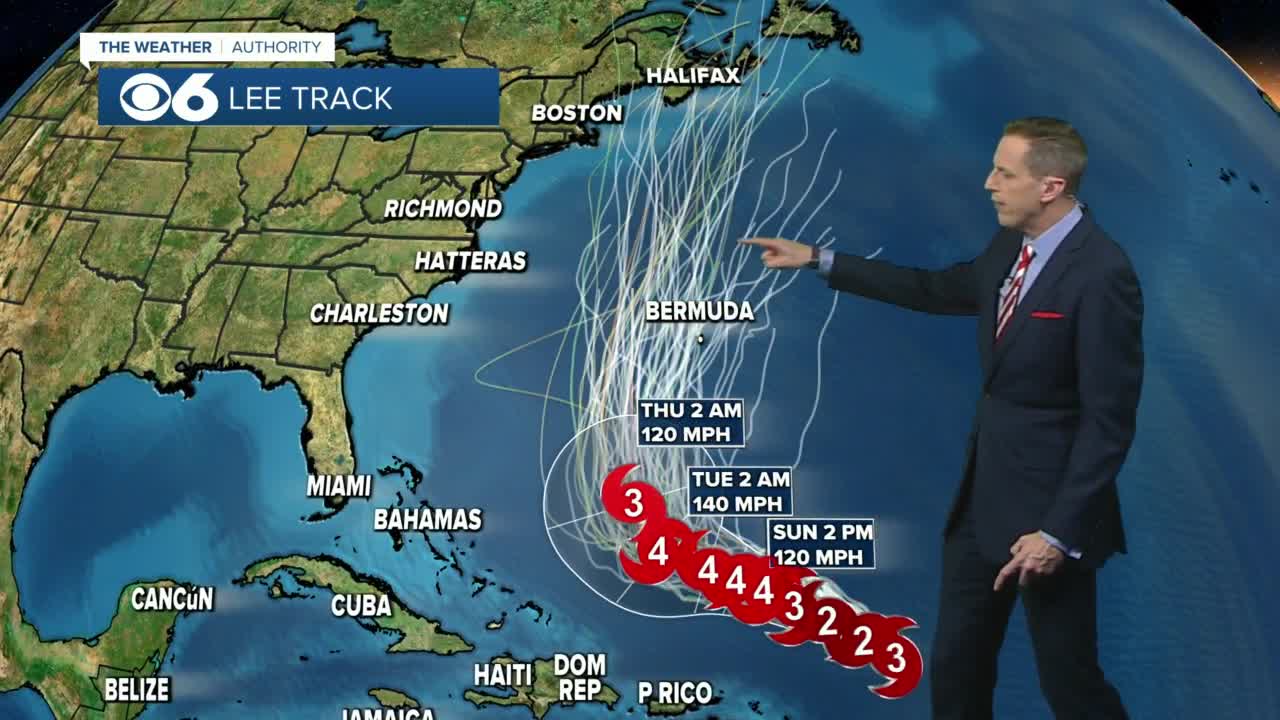
SAN JUAN, Puerto Rico — Large swells battered the northeast Caribbean on Saturday as Hurricane Lee churned nearby through open waters as a Category 3 storm.
The storm, which is not forecast to make landfall, was located about 350 miles (565 kilometers) east-northeast of the northern Leeward Islands. It had winds of up to 115 mph (185 kph) and was moving west-northwest at 12 mph (19 kph).
Earlier this week, Lee grew from a Category 1 storm to a Category 5 storm in just one day amid warm waters and limited wind shear.
“This was one of the fastest rates of strengthening in the Atlantic Basin on record,” AccuWeather said in a statement.
Lee is expected to strengthen again on Sunday and Monday, according to the National Hurricane Center.
The storm was forecast to pass well north of the northeast Caribbean in a big relief to people from the British Virgin Islands to Puerto Rico, which are still recovering from hurricanes Irma and Maria that hit in September 2017.
Tropical storm conditions were not expected for any Caribbean island, but breaking waves of up to 15 feet (5 meters) were forecast for Puerto Rico and nearby territories, with authorities warning people to stay out of the water.
“We are concerned about people and boaters who may underestimate the impacts of this passing storm,” said Capt. José Díaz of the Coast Guard sector in San Juan, Puerto Rico. “The increase in projected sea states of 10 to 15 feet severely reduces our ability to respond to a maritime distress with the full use of our resources.”

🌀Track Lee with Interactive Hurricane Tracker
The National Hurricane Center said the seas near the center of the hurricane were expected to peak at 45 feet (14 meters).
It noted that dangerous surf and rip currents were expected to hit most of the U.S. East Coast starting Sunday, but that the hurricane's impact beyond that is still unclear.
"It is way too soon to know what level of impacts, if any, Lee might have along the U.S. East Coast, Atlantic Canada, or Bermuda late next week," the center said.
Meanwhile, officials in the French Caribbean island of Guadeloupe warned of up to 3 inches (8 millimeters) of rain in a span of three hours or less for some areas, while officials in the French territories of St. Barts and St. Martin said flooding in some coastal areas was possible.
Lee is expected to remain a powerful hurricane into next week and is forecast to take a northward turn by Wednesday. However, its path after that remains unclear.
“Right now, the area in the United States that really needs to pay attention includes locations from the upper part of the mid-Atlantic coast to New England,” said AccuWeather meteorologist Bernie Rayno.
Lee is the 12th named storm of the Atlantic hurricane season, which runs from June 1 to Nov. 30 and peaks in September.
Tropical Storm Margot became the 13th named storm after forming on Thursday evening. It was located about 970 miles (1,560 kilometers) west-northwest of the Cabo Verde Islands. It had winds of up to 45 mph (75 kph) and was forecast to strengthen into a hurricane early next week. It was moving west-northwest at 12 mph (19 kph) and is expected to remain over open water.
The National Ocean and Atmospheric Administration in August forecasted between 14 and 21 named storms this season. Six to 11 of them are expected to become hurricanes, and of those, two to five might develop into major hurricanes.
In the Pacific, Hurricane Jova spun through open waters far from Mexico’s southwest coast and posed no threat to land.
It was located about 995 miles (1,600 kilometers) west of the southern tip of Baja California and was moving west-northwest at 10 mph (17 kph) with winds up to 65 mph (100 kph).


