
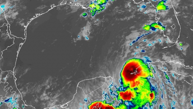


Forecasters say Tropical Storm Idalia is near hurricane strength late Monday evening, and will likely rapidly intensify in the warm Gulf of Mexico waters.
The National Hurricane Center issued a hurricane warning for Florida's Gulf Coast from the middle of Longboat Key northward to the Holocene River.
A tropical storm warning was in effect for the Florida east coast and the southeastern Georgia coast from Sebastian Inlet northward to Altamaha Sound.
The National Hurricane Center also issued a storm surge warning for Englewood northward to Indian Pass, including Tampa Bay. Parts of the Florida coast could experience inundation of up to 12 feet.
As of late Monday evening, Idalia had top sustained winds of 70 mph, just short of the 74 mph threshold of a category 1 hurricane. The storm was expected to reach hurricane status by Monday night. Thanks to winds and warm ocean temperatures in the Gulf of Mexico, the storm is forecast to rapidly strengthen through Tuesday into a major hurricane.
The storm on Monday evening was just off the western tip of Cuba, lashing that part of the island with tropical-storm-force winds. Heavy rainfall and hurricane-force winds were expected in Cuba on Monday night; A hurricane warning was in effect for the island
The National Hurricane Center expects Idalia's center to pass just west of the tip of Cuba and through the Yucatan Channel.
From there, Idalia is expected to make a beeline for the Florida Gulf Coast, gaining strength as it goes. Hurricane watches are in place from Englewood, Florida, to Indian Pass, Florida. The hurricane watch includes the Tampa area.
There is a tropical storm warning from Chokoloskee northward to the middle of Longboat Key, and from west of the Lockheed River westward to Indian Pass. While these areas are not expected to have a direct landfall from Idalia, the storm's outer bands could bring tropical storm-like conditions to the area over the next few days. A tropical storm watch was also issued for parts of Florida and Georgia's Atlantic coast. "There is a danger of life-threatening storm surge inundation along portions of the Florida Gulf Coast where a Storm Surge Warning is in effect, including Tampa Bay and the Big Bend region of Florida," the National Hurricane Center wrote. "Inundation of 8 to 12 feet above ground level is expected somewhere between Chassahowitzka and Aucilla River. Residents in these areas should follow any advice given by local officials."
SEE MORE: Why it's important for presidents to visit after disaster strikes
Officials spent Sunday encouraging residents to begin making emergency preparations.
"Anybody on the Gulf Coast,certainly from Tampa all the way up to places like Bay County, you should absolutely be vigilant right now," Florida Gov. Ron DeSantis said. "You should be following the track of the storm and making your preparations. Listen to the folks who are with emergency management, and local officials. They are the ones that are going to be issuing guidance on evacuating and any road closures."
Hurricane Ian was the last major hurricane to strike Florida, making landfall in Cayo Costa on Sept. 28, 2022. Before that, Hurricane Michael struck the Florida Gulf Coast as a Category 5 storm in 2018.
SEE MORE: What is the difference between a tropical storm and hurricane?
Trending stories at Scrippsnews.com
